CLIx i2C Pilot: Mapping activity at Government Ninder School, Rajasthan
This activity was conducted from 14 to 18 September, 2015, with Std IX students in Ninder village outside Jaipur.
After a classroom briefing to refresh their concept of maps, learnerswere ready for the outdoor activity. The tools – an Android phone, running Osmand, an app that runs without internet, with offline India maps (free software).
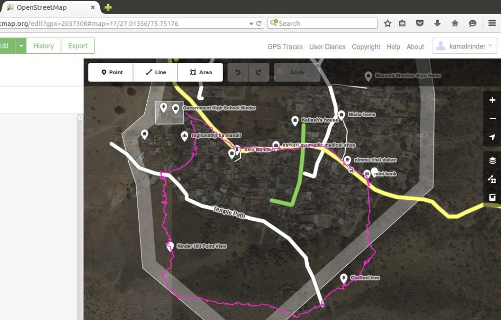
Right outside the school gates, students were shown the Osmand screen, with an icon indicating their location. This point was marked, labelled, and the walk commenced. Students watched as Osmand recorded a “bread-crumb trail” of their path, and were encouraged to identify familiar village locations – which were in turn marked on the trail. Points of interest included temples, a bank, the bus stop, shops, students’ homes. Those not wholly clued in to the activity nevertheless enjoyed the stroll, sharing village tidbits, and being photographed.

Screenshot: The walking trail (pink); streets (white and green – the yellow street pre-exists); locations (icons, labels); village boundary (thick grey line)
In class next day, the delay caused by the school internet connection was used to familiarise learners with Indic/Hindi typing– which the other students were already practising. Eventually, third party connections were pressed into service, and openstreetmaps.org accessed. The phone data from Osmand was uploaded to the website, and students began learningto view and relate satellite imagery of their village to their own knowledge.
Next came an exercise – tracing the path from school to their homes (labelled with the names they suggested – usually their fathers’ names), using the line tool to draw these village roads. Taking turns, they edited labels, drew and uploaded paths. General applause greeted each screen message about a successful upload – with even the less attentive learners clapping on cue.
As there were not enough computers to accommodate all 45 students together, in a special sharing session on the final day the 14 who had participated in the activity explained it to the rest.


Comments are closed.